When
the
ranch
land
was
first
purchased
a
number
of
old
buildings
were
located
on
the
property
where
the
lake
now
stands
as
well
as
near
the
family
camp
area.
Most
of
the
buildings
(used
for
small
logging
operations)
were
torn
down
during
the
construction
of
the
dam
and
the
lake
area.
Only
the
medics
cabin
(a
small
two
room
shack)
located
about
thirty
feet
in
front
of
the
existing
directors
cabin
and
the
ranch
house
(an
“L”
shaped
building)
located
at
the
end
of
the
auxiliary
parking
lot
remained
until
the
late
1970’s.
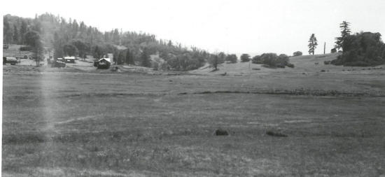
Before
the
dam
was
in
place
the
main
road
across
the
meadow
crossed
in
front
of
the
peninsula,
where
the
Chapel
is
located,
and
exited
near
the
dinning
hall.
The
small
road
that
is
used
as a boat launch that can be seen in front of the dinning hall is the last remaining portion of the main road that crossed the meadow.
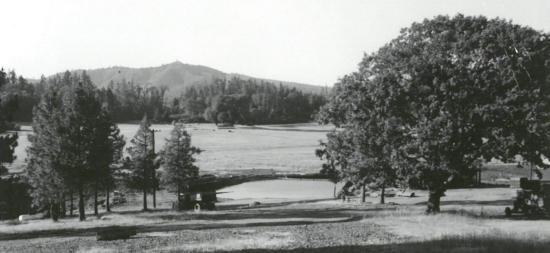
Between
Black
Oak
point
and
the
canoeing
picnic
area,
a
small
pond
once
stood.
A
natural
spring
that
is
located
at
the
bottom
of
the
lake
as
well
as
an
existing
spring
that
is
located
across
the
main
road
near
O’Reily’s
outpost
formed
this
pond.
It
is
assumed
that
this
pond
was
used
as
a
mill
pond
for
the
logging
operations,
as
a
small
building
was
located
next
to
it,
which
could
have
been
the
sawmill.
Other
than
a
few
bushes and some small scrappy trees, the meadow was a big open grassy field perfect for a potential lake.
CAMPS A, B & C
The
original
drawings
for
the
scout
reservation
called
for
three
separate
camps
known
as
Camp
A,
Camp
B
and
Camp
C.
Each
camp
would
be
large
enough
to
accommodate
200
Scouts
(although
that
limit
has
been
pushed
to
over
600
Scouts
and
Scouters
in
recent
years).
Camp
A
would
be
the
main
camp
that
surrounded
the
lake.
Camp
B
was
to
be
located
on
the
west
side
of
Eagle
Summit
in
the
upper
meadow
area.
Camp
C
was
to
be
built
on
the
East
side
of
Eagle
summit
between
Tan
Oak
Cathedral
and
Mellow
Marsh/Haunted
Springs
where
the
lodge
pole
climbing
outpost
once
resided
and
the
overnight
corral
outpost
now
camps.
The
secondary
sites
of
Camp
B
and
Camp
C
would
both
have
swimming
pools,
a
campfire
site
and
areas
for
eleven
troop
campsites
as
well
as
a
staff
village
and
food
distribution
building.
Only
one
structure
for
the
other
two
camps
was
ever
completed,
the
kybo
in
the
area
that
was
designated
as
campsite
9
in
Camp
C.
This
outhouse
was
built
to
maintain
the
Scout
Reservation
designation
as
one
camping
area
did
not
constitute
a
reservation.
The
two-seater
kybo
can
still
be
found
today
alone
and
silent
at
the
top
of
the
hill
waiting
for
the
ghost
Scouts
of
Camp
C.
Each
camp
was
to
be
self-sufficient
but
lack
of
funds
did
not
allow
for
these
other
two
camps
to
be
built.
However
full
color
drawings
for
the
secondary
camps
still
exist
and
are
quite
fascinating
to
look
at
and
ponder
what
it
would
have
been
like
with
three
camps.
The
camp
rivalries
and
competitions
would
have
been
great.
One
additional
area
of
camp
that
was
never
realized
was
near
the
entrance
to
the
camp
off
of
Canyon
Road.
The
level
area
where
the
remains
of
an
old cabin are was to be the family camping area as well as maintenance buildings for all three camps.
In
October
of
1961
members
of
the
Oakland
and
San
Lorenzo
Rotary
club
donated
$15,000
in
materials
and
labor
to
construct
the
first
two
major
buildings
at
the
camp,
the
Admin
building
and
the
trading
post/commissary.
The
admin
building
was
constructed
and
financed
by
the
Oakland
Rotary
club
and
would
be
constructed
with
a
shingle
roof,
plywood
interior
and
a
wide
front
porch.
The
building
would
also
contain
a
small
kitchen,
shower
and
toilet
facilities.
The
main
room
of
the
building
would
be
used
for
both
staff
dinning
and
office
tasks.
A
fifteen
foot
addition
to
the
building
in
the
late
60’s
would
add
a
staff
shower
house,
first-aid
room
and
camp
office
to
the
east
side
of
the
building.
If
you
look
at
the
cement
porch
and
the
roofline
you
can
see
where
the
original
building
stopped
and
the
addition
was
added.
Although
the
interior
of
the
building
has
changed
much
over
the
years,
the
outside
of
the
building
looks
the
same
as
it
did
in
1961.
The
other
major
construction
project
was
the
building
of
the
original
commissary/trading
post
(today's
Handicraft
building)
by
the
Rotary
club
of
San
Lorenzo.
This
building
was
constructed
in
an
area
that
was
central
to
the
camp
during
its
first
few
years.
If
you
explore
the
handicraft
building
you
will
notice
that
the
side
that
faces
the
Scoutcraft
area
has
pull-up
doors,
as
this
was
the
trading
post
for
the
camp.
The
side
that
faces
the
lake
is
where
the
Scouts
picked up their food and supplies for the Jamboree style cooking. The back of the building that faces site 4 (Sky High) was the loading dock.
500 TREES ARE PLANTED
At
the
beginning
of
1962,
100
Scouts
from
the
Central
District
of
the
Oakland
council
led
by
Scout
Commissioner
Roger
Day
planted
over
500
trees
on
the
southeast
corner
of
the
lake.
This
area
was
to
be
a
picnic
grounds
for
the
parents
of
the
Scouts.
If
you
look
across
the
lake
a
number
of
those
trees
are
still
thriving
today
and
some
of
the
metal
containers
that
shielded
the
trees
can
be
found
lying
around.
A
few
months
later
the
camp
began
to
take
further
shape
as
Kaiser
Steel
of
Oakland
donated
five
tons
of
metal
pipe
that
would
be
used
to
lay
the
lateral
water
lines
for
the
three
camps.
It
is
unclear
if
any
of
the
water
lines
for
the
two
other
proposed
camps
were
ever
laid.
However
walking
from
the
location
of
Camp
C
down
to
Haunted
Springs
(Pear
Orchard
springs)
you
can
find
metal
water
lines
along
side
the
hill.
It
may
be
possible that some of the lines to the springs were laid in anticipation of building the other camps.
In
May
of
1962
the
Berkeley
geologist
made
a
final
visit
to
the
dam
site
to
obtain
samples
of
the
fill
materials
for
testing.
During
this
visit,
an
eight-foot
vertical
cut
was
made
into
the
road
that
paralleled
the
creek
as
well
as
a
seven-foot
trench
was
dug
in
the
valley
where
the
fill
material would be “borrowed”. This material showed it to be a uniform gritty silty clay that tested excellent as a fill material.
In
April
of
1963
with
the
“Specifications
for
Construction
of
Scout
Lake
Dam”
complete,
the
council
sent
bids
out
for
the
building
of
the
dam.
The
expected
cost
of
the
dam
and
the
necessary
grading
was
estimated
to
be
around
$93,000.
The
dam
would
be
51
feet
high,
290
wide
and
ultimately
hold
back
386
million
gallons
of
water
with
an
80-acre
lake.
Over
9000
cubic
yards
of
material
would
need
to
be
excavated
and
62,000
cubic
yards
of
fill
material
borrowed
for
the
completion
of
the
dam.
The
maximum
depth
of
the
lake
would
be
46
feet
at
which
point
water
begins
to
flow
over
the
spillway.
The
elevation
of
the
spillway
is
listed
as
1,921
feet
above
sea
level
while
the
original
creek
bed
at
the
bottom
of
the
lake
is
at
1875
feet.
A
funny
aspect
contained
within
the
specifications
for
the
dam
is
in
Division
“C”,
Section
7
–
Guarantee
of
Work.
The
camp
had
a
one-year
guarantee
on
the
failure
of
the
dam
against
any
defects
in
workmanship
and
inferior
materials.
The
water
from
the
lake
would
be
used
as
the
drinking
source
for
the
camp
through
a
filtration
plant
to
be
located
below
the
dam.
The
water
would
be
pumped
up
to
two
100,000-gallon
redwood
tanks
on
the
hillside
above
the
lake
and
gravity
fed
to
the
campsites.
The
lake
created
by
the
dam
would be the largest on the West coast created specifically for Boy Scout aquatic activities.
In
May
of
1963
the
Camp
Flag
Pole
was
erected
on
the
west
end
of
the
Admin
building.
The
flag
pole
was
presented
by
Troop
211
of
the
Lake
District in honor of Herbert Hauser (executive board member and first Silver Beaver recipient of the Oakland Area Council, 1929-1962).
DEDICATION OF BUILDINGS AND GROUND BREAKING FOR DAM
One
month
later
on
June
10,
1963
with
the
construction
bid
process
closed
for
the
dam,
over
200
people
(including
William
Knowland
publisher
of
the
Oakland
Tribune,
who
was
in
charge
of
the
fundraising
efforts
for
the
new
camp)
attended
the
gala
groundbreaking
ceremonies
for
the
dam
and
also
the
completion
of
the
trading
post
and
commissary
building
by
the
Rotary
Club.
Construction
of
the
dam
would
commence
immediately
to
ensure
the
camp
was
open
for
the
1964
season.
The
building
of
the
dam
required
the
removal
of
some
small
buildings,
the
moving
of
power
lines
and
the
building
of
a
new
road
across
the
dam.
Also
a
number
of
small
oak
trees
had
to
be
removed
from
the
dam
site
and
the
waterfront
area
had
to
be
graded
and
conditioned
for
swimming
and
aquatic
use.
With
all
the
work
that
needed
to
be
done,
the
dam,
spillway, bridge and new main road would still be completed in the fall of that same year.
THE GATES TO THE DAM ARE CLOSED
On
October
31,
1963
the
single
18
inch
diameter
pipe
and
its
two
flood
gates
(one
on
the
inlet
and
one
on
the
outlet)
were
closed-off
and
the
small
beginnings
of
the
lake
driven
by
the
various
springs
and
winter
rains
began
to
backup
behind
the
dam.
It
would
take
two
full
winters
for
the
lake
to
reach
its
capacity
and
overflow
the
spillway
into
Boy
Scout
creek
below
the
dam.
Although
the
lake
would
be
ready
for
use
by
summer
the
completion
of
the
campsites
still
had
a
long
way
to
go.
By
December
of
1963
only
two
campsites
had
been
completed
and
five
more still needed to be built.
THE COUNCILS MERGE
During
the
first
months
of
1964
a
major
change
took
place
at
the
council
that
had
been
in
the
works
for
almost
four
years.
On
February
10,
1964
atop
Yerba
Buena
Island
in
the
middle
of
the
bay,
the
flags
for
the
Oakland
Area
Council
and
the
San
Francisco
Council
were
lowered
for
the
last
time
during
a
ceremony
where
the
two
councils
merged
and
the
San
Francisco
Bay
Area
Council
flag
was
raised.
With
the
raising
of
the
SFBAC
flag
there
now
were
six
camps
in
the
united
council
(Dimond-O,
Los
Mochos,
Camp
Loomer,
Willits
Scout
Reservation,
Camp
Royaneh
and
Camp
Lilienthal).
With
the
cost
to
operate
so
many
camps
the
two
undeveloped
camps
at
the
Scout
Reservation
(Camps
B
&
C)
were
dealt
a deathblow and would never be built.
In
June
of
1964,
16
years
after
the
closing
of
Camp
Dimond,
Willits
Scout
Reservation
the
newest
camp
of
the
Oakland
Area
Council
(now
the
San
Francisco
Bay
Area
Council)
opened
for
its
first
summer
camp.
During
the
first
summer,
there
were
only
seven
campsites
to
choose
from
(Big Dipper, Wishbone, Sailor’s Rest, Sky High, Madrone, Moss Shadows, and Sunrise Ridge).
Camp History (1948 - 1964)

Wente Scout Reservation, 5401 Canyon Road, Willits, CA 95490
Golden Gate Area Council-BSA, 6601 Owens Drive, Suite 100, Pleasanton, CA 94588 | PH: 925.674.6100
email: info@wentescoutreservation.org | www.wentescoutreservation.org

Copyright ©, All Rights Reserved


- Aerial View of Campsites
- Loomer Subcamp Camping Area
- -> Oak Flats
- -> Turkey's Roost
- -> Dimond-W
- -> 12 O'Clock High
- The Ridge Subcamp Camping Area
- -> Sleepy Hollow
- -> Big Dipper
- -> Little Dipper
- -> Trail's End
- Wagner Subcamp Camping Area
- -> Wishbone
- -> Sailors Rest
- Fire Trail Subcamp Camping Area
- -> Sky High
- -> Madrone
- -> Moss Shadows
- -> Sunrise Ridge